NewsData stories
Data stories2 October 2023

Mapping the evolution of Unguja’s road infrastructure

Unguja is one of the major islands in the archipelago of Zanzibar. Zanzibar is an island state that is part of the United Republic of Tanzania and has its own autonomous system of land administration. Starting in 2003, the Finnish Government provided financial support to the government of Zanzibar for the implementation of the Sustainable […]

Resilience Academy

Photo: Resilience Academy

Unguja is one of the major islands in the archipelago of Zanzibar. Zanzibar is an island state that is part of the United Republic of Tanzania and has its own autonomous system of land administration.

Starting in 2003, the Finnish Government provided financial support to the government of Zanzibar for the implementation of the Sustainable Management of Land and Environment (SMOLE) project. One of the initiatives within this project involved the creation of new digital topographic maps for the Zanzibar archipelago. Before 2004, the latest topographic maps of Unguja were produced in the 80’s and they were still in use, for example, when researching infrastructure networks. However, significant changes in land use had taken place in the area, for example due to rapid urbanization and environmental changes so the previous map contained outdated data regarding the road infrastructure in the area. Aerial photographs for both the main islands, Unguja and Pemba, along with their 52 smaller islets were produced at the time for creating a new road map in 2004.

Humid tropical climates tend to have a dense cloud cover most of the time, and this is the case with Zanzibar. Thus taking clear aerial photos of Zanzibar is particularly challenging as clouds weaken the visibility from a bird’s-eye view. However, as good aerial photographs as possible were produced for both Unguja and Pemba with the help of a low-flying airplane. This process was gradual and took about a year. Subsequently photogrammetry stations and GIS (geoinformatics information system) software were used in digitizing the most important characters from the aerial pictures into informative and useful maps. This is how the Unguja road dataset was made.
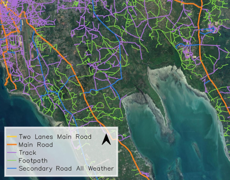
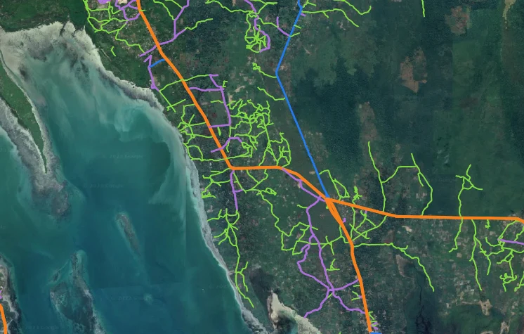
By comparing the 2004 dataset with the data produced in the 1980’s and the current road data from the area, you can get interesting information about changes in road infrastructure in Unguja over a period of forty years. This information could be used, for example, for research purposes.

Share

Related articles

News30 Jun 2026

Building climate agency through geospatial and challenge-based learning – reflections of the Shape2Gether project

Authors: Niina Käyhkö, Sanna Mäki, Jukka Käyhkö   The Erasmus+ higher education cooperation project “Shape2Gether” (Shaping Innovations in Education for Sustainable Development: Contextualizing Geosciences, New Technologies, and Serious Games with Climate Change, 2024–2026) brought together seven university partners and one company from across Europe to transform education for sustainable development. The project aimed to integrate […]

Read more →
News, Training1 Apr 2026

Resilience Academy delivers four-day training on geospatial data collection, quality management, and sharing in the Climate Risk Database across two Tanzanian cities.

By Msilikale Msilanga, Amedeus Kimaro and Massoud Hamad In March 2026, the Resilience Academy conducted two rounds of a four-day training on Geospatial Data Collection, Data Quality Management and Sharing in the Climate Risk Database. The first round took place in Tanga from 9 to 12 March, and the second round followed in Mwanza from […]

Read more →
News9 Mar 2026

Shaping Together in Finland – Sharing the Shape2Gether Experiences in Turku

The Shape2Gether -project is about shaping innovations in education for sustainable development: contextualizing geosciences, new technologies, and serious games with climate change. If you wish to explore insights from the three summer schools that were organized during this project, you can find the Norway blog post here, the Malta blog post here, and the Germany […]

Read more →
News10 Jan 2026

85 students and alumni engaged in the 2025 Data Visualization Challenge to develop geovisualization solutions supporting urban water and climate resilience decision-making in Tanga and Mwanza.

By Msilikale Msilanga Young people develop the most robust skills when they engage in hands-on work on real-world problems. Resilience Academy organized another visualization challenge for 2025 as part of ProWA-SASA project, collaborating with partners like GIZ and ProWAS SASA Partners from Mwanza and Tanga cities. This initiative provided university students and recent graduates with […]

Read more →