NewsNews
News27 March 2024

Enhancing Timber Harvesting Planning with Centimeter Precision: The Role of Emlid Reach RS2 GPS Receivers in GeoICT4e’s Educational Transformation

By Dr. Ernest Mauya and Msilikale Msilanga The aim of GeoICT4e has been to enhance the management and teaching capacities of Tanzanian universities in the are of geospatial and ICT education, with a clear goal of improving employment opportunities for graduates. By concentrating on crucial aspects of educational capacities, GeoICT4e empowers staff to plan and […]

Msilikale Msilanga

Resilience Academy

Photo: Resilience Academy

By Dr. Ernest Mauya and Msilikale Msilanga

The aim of GeoICT4e has been to enhance the management and teaching capacities of Tanzanian universities in the are of geospatial and ICT education, with a clear goal of improving employment opportunities for graduates. By concentrating on crucial aspects of educational capacities, GeoICT4e empowers staff to plan and implement multi-competence learning solutions, promotes open access to digital e-learning assets, and bolsters students’ digital skills and multi-competences. This initiative also advances institutional uptake and management capacities of Higher Education Institutions (HEIs), particularly in broadening the scope of geospatial-ICT education to reach a wider audience.

Central to the GeoICT4e project is the transformation of education through students’ multi-competence learning (MCL) process, rooted in challenge-based learning principles. This approach enhances students’ competences in four key knowledge domains: understanding complex societal problems, utilising digital geospatial data and open-source Geo-ICT technologies, developing collaborative abilities and professional confidence in multi-stakeholder teams, and designing climate-smart solutions for social, environmental, and economic sustainability amidst global change-induced uncertainties. This MCL process optimises socially innovative geospatial and ICT education transformation.

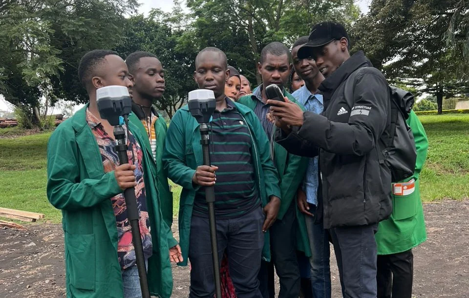
One of the tangible outcomes of the GeoICT4e project’s efforts at the Sokoine University of Agriculture (SUA) is the integration of EMLID Reach RS2 Differential GPS units into the educational resources. These devices, are current being utilised by students during their industrial attachments for precision planning of timber harvesting operations in their training forests at Arusha, Tanzania. This initiative represent a significant technological leap in Timber Harvesting Operations with a precision range of 10 to 30 cm. This enhancement in precision planning for timber harvesting is a clear indication of the project’s impact on teaching and learning facilities, demonstrating the practical application of GeoICT4e’s goal to advance geospatial-ICT education and prepare students for the modern workforce.

Share

Related articles

News30 Jun 2026

Building climate agency through geospatial and challenge-based learning – reflections of the Shape2Gether project

Authors: Niina Käyhkö, Sanna Mäki, Jukka Käyhkö   The Erasmus+ higher education cooperation project “Shape2Gether” (Shaping Innovations in Education for Sustainable Development: Contextualizing Geosciences, New Technologies, and Serious Games with Climate Change, 2024–2026) brought together seven university partners and one company from across Europe to transform education for sustainable development. The project aimed to integrate […]

Read more →
News, Training1 Apr 2026

Resilience Academy delivers four-day training on geospatial data collection, quality management, and sharing in the Climate Risk Database across two Tanzanian cities.

By Msilikale Msilanga, Amedeus Kimaro and Massoud Hamad In March 2026, the Resilience Academy conducted two rounds of a four-day training on Geospatial Data Collection, Data Quality Management and Sharing in the Climate Risk Database. The first round took place in Tanga from 9 to 12 March, and the second round followed in Mwanza from […]

Read more →
News9 Mar 2026

Shaping Together in Finland – Sharing the Shape2Gether Experiences in Turku

The Shape2Gether -project is about shaping innovations in education for sustainable development: contextualizing geosciences, new technologies, and serious games with climate change. If you wish to explore insights from the three summer schools that were organized during this project, you can find the Norway blog post here, the Malta blog post here, and the Germany […]

Read more →
News10 Jan 2026

85 students and alumni engaged in the 2025 Data Visualization Challenge to develop geovisualization solutions supporting urban water and climate resilience decision-making in Tanga and Mwanza.

By Msilikale Msilanga Young people develop the most robust skills when they engage in hands-on work on real-world problems. Resilience Academy organized another visualization challenge for 2025 as part of ProWA-SASA project, collaborating with partners like GIZ and ProWAS SASA Partners from Mwanza and Tanga cities. This initiative provided university students and recent graduates with […]

Read more →